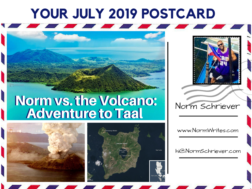
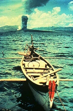
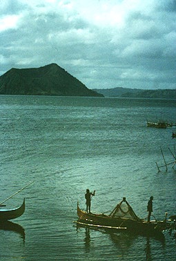
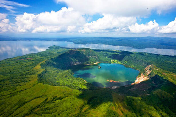
Last week, I had the opportunity to revisit an extraordinary place here in the Philippines – the Taal Volcano. Located on an island in the middle of a rugged and windswept lake, we actually hiked up to the volcano’s crater for an up-close, stunning view.
Located only 35 miles outside of Manila in the upscale lakeside region of Tagaytay, Taal is a remarkable feat of geography and geology alike.
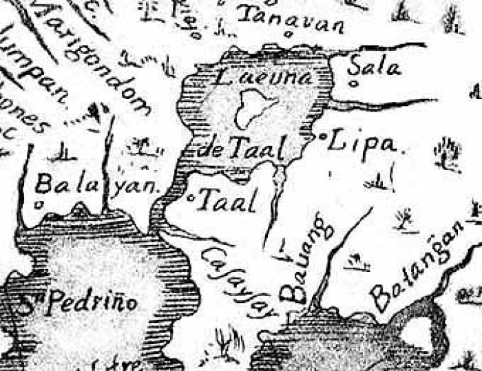
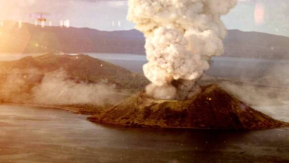
Get this: the Taal Volcano sits on an island in a lake in the middle of a volcanic crater on a larger island, which sits on a huge lake on the giant island of Luzon.
Located only 35 miles outside of Manila in the upscale lakeside region of Tagaytay, Taal is a remarkable feat of geography and geology alike.
Get this: the Taal Volcano sits on an island in a lake in the middle of a volcanic crater on a larger island, which sits on a huge lake on the giant island of Luzon.

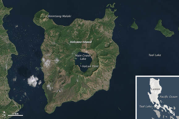
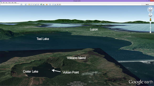
If we follow that inside-out, tiny Vulcan Point Island sits inside the Main Crater Lake, which is on Volcano Island and surrounded by Taal Lake sitting in a volcanic “caldera”, which is on the Philippines main island of Luzon, surrounded by the Pacific Ocean. Wow.
That’s like something out of a Pirates of the Caribbean movie…except it’s too fantastical to be made up. According to my research, it’s also the only one of its kind in the world
That’s like something out of a Pirates of the Caribbean movie…except it’s too fantastical to be made up. According to my research, it’s also the only one of its kind in the world
Of course, there are plenty of active volcanos in the Philippines (53 to be exact) since it sits on the western Pacific edge of the Ring of Fire. Most of them are dormant, but some still spit lava when we anger the gods, like on the island of Camiguin, which is home to seven volcanos but only five towns.
Mount Pinatubo provided one of the largest eruptions in the world in 1991, causing the overnight evacuation of the USA’s naval and air force bases nearby. That’s also why there’s so much seismic activity in the Philippines (aka earthquakes that scare the shit out of you).
Mount Pinatubo provided one of the largest eruptions in the world in 1991, causing the overnight evacuation of the USA’s naval and air force bases nearby. That’s also why there’s so much seismic activity in the Philippines (aka earthquakes that scare the shit out of you).
But Taal still holds a fiery, menacing presence over the surrounding countryside, erupting 34 times since Spanish friars first discovered it in 1572 and started keeping written records. For that reason, it’s been designated a Decade Volcano, one of only 16 in the world, warranting close monitoring to prevent further natural catastrophe.
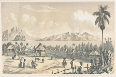
Taal, which means native or original in the Philippines aboriginal language, is also notable because it’s one of the lowest volcanos in the world, cresting at only 1,020 feet above the onyx-colored beaches, lakeshores, and tropical jungle below.
Taal, which means native or original in the Philippines aboriginal language, is also notable because it’s one of the lowest volcanos in the world, cresting at only 1,020 feet above the onyx-colored beaches, lakeshores, and tropical jungle below.
 |  |
That wasn’t always the case, as the Taal peak used to be a mountain reaching 18,000 feet high. But every time the volcano erupts, rocks, dust, and magma are shot into the sky, knocking the mountain down like a sandcastle and reshaping the whole island.
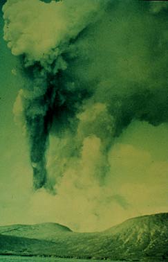
The most powerful of all Taal eruptions took place in 1754, when the volcano raged smoke, fire, and ash a full 200 days nonstop from May 15 to December 1!
The most powerful of all Taal eruptions took place in 1754, when the volcano raged smoke, fire, and ash a full 200 days nonstop from May 15 to December 1!
 |  |
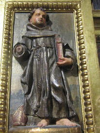
A Catholic priest stationed at Taal at the time of the 1754 eruption, Friar Buencuchillo, wrote this account:
“The volcano quite unexpectedly commenced to roar and emit, sky-high, burning flames intermixed with glowing rocks which, falling back upon the island and rolling down the slopes of the mountain, created the impression of a large river of fire.”
“The volcano quite unexpectedly commenced to roar and emit, sky-high, burning flames intermixed with glowing rocks which, falling back upon the island and rolling down the slopes of the mountain, created the impression of a large river of fire.”
While there were plenty of volcanic explosions and seismic events over the ensuing decades and centuries, the next huge eruption occurred in 1911. That explosion was so profound that it obliterated the main crater floor completely, allowing water to fill in and creating a volcanic lake. The volcano started raging on the night of January 27 and by the end of the next day, there were about 240 total seismic shocks, 10 of which were severe.
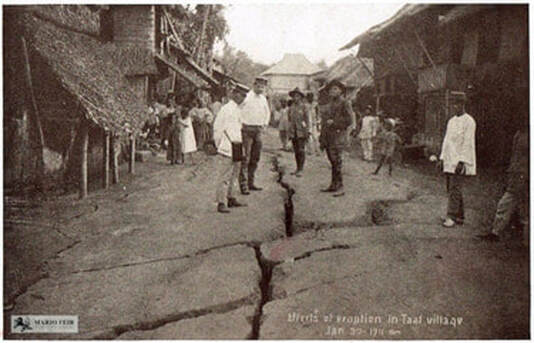
With Taal still shooting fire and debris on the night of January 30, residents of Manila who saw the flashes of light 30 miles away first thought it was a thunder and lightning storm. But they soon saw a massive mushroom cloud of debris and dust, illuminated by sparkling fields of electricity, rising until the eruption ended and the cloud disbursed around 2:30 am.
By mid-morning, a blanket of dust and ash settled on Manila, covering streets and the inside of homes, leaving a thick layer on floors, furniture, and all surfaces. In total, that eruption shot about 80 million cubic meters of debris into the air, dissipating it over an area of 770 square miles. The titanic sound from the eruption was heard more than 600 miles away.
By mid-morning, a blanket of dust and ash settled on Manila, covering streets and the inside of homes, leaving a thick layer on floors, furniture, and all surfaces. In total, that eruption shot about 80 million cubic meters of debris into the air, dissipating it over an area of 770 square miles. The titanic sound from the eruption was heard more than 600 miles away.
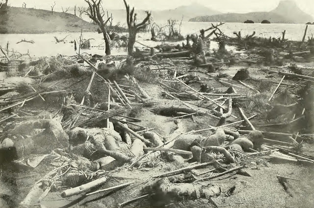 | 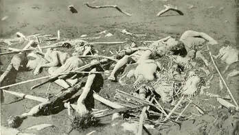 |
Back in 1911, the area around Taal island and the lake region was far less populated than it is today, but the official death toll still reached 1,335. The true loss of life is estimated to be up to five times more.
At that time, there were seven barangays – small fishing villages or farming communities – on the island. They were all completely wiped out, sparing no man, woman, child, and turning the 702 cattle on the island into smoking carcasses.
At that time, there were seven barangays – small fishing villages or farming communities – on the island. They were all completely wiped out, sparing no man, woman, child, and turning the 702 cattle on the island into smoking carcasses.
 | 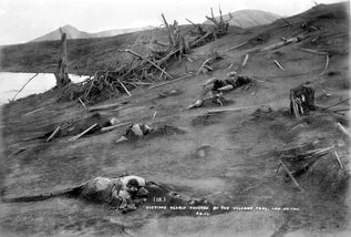 |
Buried mid-stride as they only managed one or two steps in a futile attempt to run, the deceased were found to have perished from boiling steam and scalding volcanic mud, melting trees and nipa huts in its path.
Remember that this was well before seismologists and meteorologists could measure and share data, so there was no warning, and only grainy black and white photos of the event exist.
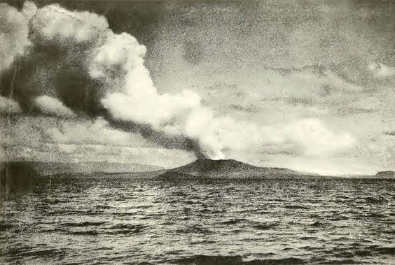
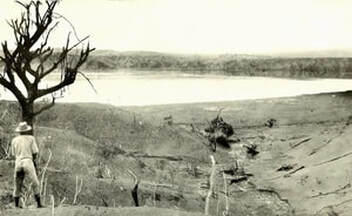
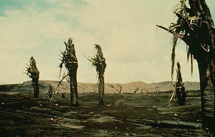
While that was the deadliest saga in the history of Taal, the ring of fire exploded violently once again some 54 years later in 1965. During that eruption, ash and debris were shot a full 12 miles straight up into the atmosphere.
Remember that this was well before seismologists and meteorologists could measure and share data, so there was no warning, and only grainy black and white photos of the event exist.
While that was the deadliest saga in the history of Taal, the ring of fire exploded violently once again some 54 years later in 1965. During that eruption, ash and debris were shot a full 12 miles straight up into the atmosphere.
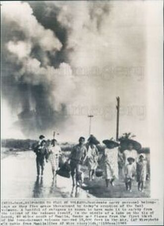 |  |
The eruption of '65 was different because it was actually caused when underground magma hit the lake water, creating what’s called a cold blast or base surge (the scientific name is 'phreatomagmatic eruption’).
Traveling like a supercharged typhoon of ash, mud, and boulders, it screamed furiously across the lake, crushing villages and jungle canopy at the water’s edge two and a half miles away, killing about a hundred people.
The other difference was that in 1965, more people owned cameras, so there are more photos from during and after the eruption, including one shot of people on the “mainland” fleeing with suitcases in hand.
The blast was so powerful that it rearranged the landscape of the island, cutting a new crater that was one mile long and 1,000 feet wide.
No significant eruption has taken place since 1977, but plenty of minor disruptions, toxic gas leaks, and seismic activity occur periodically. Those include rumbling threats in 1991 (when Mount Pinatubo erupted), 1992, 1994, and June of 2009 most recently. For that reason, it warrants careful monitoring with advanced scientific instruments by the Philippine Institute of Volcanology and Seismology.
No significant eruption has taken place since 1977, but plenty of minor disruptions, toxic gas leaks, and seismic activity occur periodically. Those include rumbling threats in 1991 (when Mount Pinatubo erupted), 1992, 1994, and June of 2009 most recently. For that reason, it warrants careful monitoring with advanced scientific instruments by the Philippine Institute of Volcanology and Seismology.
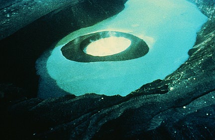 |  |
You’re also not allowed to swim in the crater lake inside the Taal Volcano anymore. While a few of the shoreline areas are inhospitable but safe to swim in, other parts of the lake are so hot that your skin would burn right off if you jumped in. Or, the waters contain poisonous gases that instantly kill all of the livestock on the island when released by seismic activity.
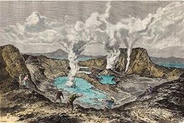
That’s also where the volcanic lake’s water gets its majestic emerald color, but there are no fish under the water. That color has changed over time, too.
Before the 1911 eruption that redrew the map, the 18-mile diameter Taal lake actually had several openings because it was lower than sea level, with a green lake, a rusty red lake, and a bright yellow lake based on the minerals and gases it was interacting with. Some were so hot, steam billowed off of them incessantly.
 |  |
But, now, things have settled into one massive lake, filling most of the Taal caldera.
The most telling sign of an impending eruption would be a precipitous rise in the lake’s water temperature. For example, the water temperature rose from a bath-water-like 86 degrees Fahrenheit to a scalding 113 degrees right before it erupted.
Taal will blow again - it’s just a matter of when and how big – and that’s the reason the government has banned the public from living there, so there are no official towns or barangays.
Of course, in true Philippines fashion, no one listens, and the island is now settled by a few thousand desperately poor people who found their way to the island. They risk the poisonous gases and possible eruption in order to scratch out a humble living. They fish the lager lake or plant crops in the magically-enriched volcanic soil. Many now capture a buck or two from the steady stream of tourists visiting the island, acting as tour guides, tending to the horses, selling coconuts or water bottles, and charging made-up “official” fees.
The locals, who don’t even have a name (like Taalians?) because no one is actually from there and they aren’t supposed to be there, live in makeshift nipa huts and sunbaked concrete communities, many of them built right on the volcanic ash. There are a few churches, remnants of NGOs or Catholic mission work, no electricity (only solar power and generators), and no government-sponsored roads, clinics, or public schools.
The locals, who don’t even have a name (like Taalians?) because no one is actually from there and they aren’t supposed to be there, live in makeshift nipa huts and sunbaked concrete communities, many of them built right on the volcanic ash. There are a few churches, remnants of NGOs or Catholic mission work, no electricity (only solar power and generators), and no government-sponsored roads, clinics, or public schools.
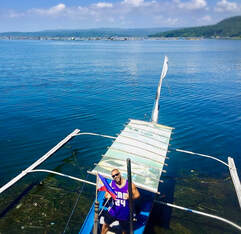
But we weren’t trying to flee the volcano this sunny day in July – we were trying to actually go to it, boating over to the island, hiking up to the volcano, and entering the crater.
Stay tuned for my account of that adventure in next month’s postcard!
Stay cool, everyone!
Norm :-)
But we weren’t trying to flee the volcano this sunny day in July – we were trying to actually go to it, boating over to the island, hiking up to the volcano, and entering the crater.
Stay tuned for my account of that adventure in next month’s postcard!
Stay cool, everyone!
Norm :-)
 RSS Feed